Kunlun Mountains: The Mythical Backbone of China's Silk Road
Most people have heard of the Himalayas. Far fewer have heard of the Kunlun.
That gap says less about the mountains themselves and more about how the world has chosen to look at Asia. Because by almost any measure, the Kunlun range is the more ancient, the more mythologically charged, and in many ways the more consequential of the two. The Himalayas define a border. The Kunlun define a civilization.
Stretching over 3,000 kilometers across the heart of Central Asia, the Kunlun Mountains form the geographic spine of China's Silk Road — the wall that separated the desert from the plateau, the route that guided merchants and pilgrims for two thousand years, and the sacred ground where Chinese mythology placed the origins of the world itself.
This article takes you from myth into landscape, and from landscape into a journey. By the end, you will understand why the Kunlun deserves to be on every serious traveler's map of Asia.
1. What Are the Kunlun Mountains?
 The Kunlun Mountains run approximately 3,000 kilometers from the Pamir Plateau in the west to the borders of Sichuan province in the east, passing through Xinjiang, Xizang, and Qinghai along the way. That makes them one of the longest mountain chains in Asia — longer than the European Alps, longer than the Rockies, and comparable in scale to the entire breadth of Western Europe.
The average elevation sits between 5,500 and 6,000 meters above sea level. The highest peak, Liushi Shan, reaches 7,649 meters — making it taller than anything in North America or Europe, though it remains largely unknown outside of specialized mountaineering circles. The range forms the natural boundary between two of Asia's most dramatic landscapes: the Tarim Basin to the north, home to the Taklamakan Desert, and the Tibetan Plateau to the south.
Geologically, the Kunlun and the Himalayas are related — both products of the same tectonic collision between the Indian and Eurasian plates. But they are not the same system. The Himalayas run roughly east-to-west along the southern edge of Xizang, while the Kunlun runs along the northern edge. Think of Xizang as the table, the Himalayas as its southern rim, and the Kunlun as its northern wall. Between them lies the highest and largest plateau on Earth.
So why do most Westerners know one and not the other? The answer is largely a matter of access and narrative. The Himalayas border Nepal and India, countries that were long open to Western travelers, mountaineers, and journalists. The Kunlun lies deep within Xinjiang and Qinghai — historically remote, logistically challenging, and only recently opened to independent travelers. The mountains are not hidden. They simply have not yet had their moment in the English-language imagination.
2. Kunlun Mountains in Chinese Mythology
If the Himalayas are Asia's geographic crown, the Kunlun are its mythological heart.
In classical Chinese cosmology, the Kunlun Mountains are known as 万山之祖 — the Ancestor of All Mountains. This is not merely a poetic title. In the ancient Chinese worldview, the Kunlun were understood as the axis of the world, the point where heaven and earth came closest, the source from which all rivers, all mountains, and all sacred geographies radiated outward. It would not be an overstatement to compare their status in Chinese mythology to that of Mount Olympus in the Greek tradition — except that the Kunlun carry an even deeper metaphysical weight.
The most famous resident of the Kunlun in Chinese mythology is Xi Wangmu (西王母), the Queen Mother of the West. Her palace, according to Taoist ure, stood at the summit of the Kunlun, surrounded by jade walls and guarded by divine beasts. She was the keeper of the peaches of immortality, the sovereign of the female principle of the universe, and the figure to whom even the Yellow Emperor came to seek wisdom. In early Taoist texts, her mountain was not merely a place — it was a threshold between the mortal world and the divine.
The mythological reach of the Kunlun extends into hydrology as well. Ancient Chinese texts describe the Yellow River and the Yangtze as originating in the Kunlun — a geographical claim that is partly true in the modern scientific sense, since both rivers do draw from the broader Qinghai-Tibet Plateau system, with headwaters that lie in the Kunlun's eastern reaches.
Perhaps no material connection to the Kunlun is more tangible than jade. The white and celadon nephrite jade that has defined Chinese material culture for over five thousand years comes largely from the riverbeds flowing down from the Kunlun into the Hotan (Khotan) region of Xinjiang. The Jade Road, some scholars argue, preceded the Silk Road — and it ran directly along the northern face of the Kunlun. When ancient Chinese emperors wore jade, they were wearing the mountain.
3. The Kunlun Mountains and the Silk Road
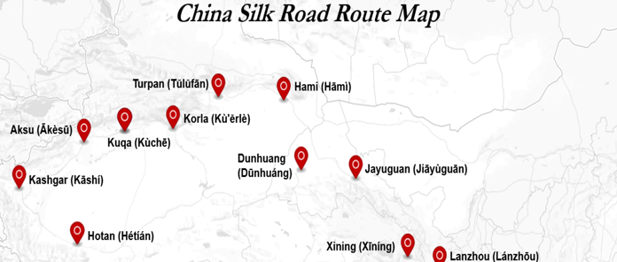
The Silk Road was never a single road. It was a network of routes, and the choice of which route a caravan took depended on the season, the political situation, and the nature of the goods being carried. One of the most important of these routes — the Southern Silk Road — ran directly along the northern foot of the Kunlun Mountains.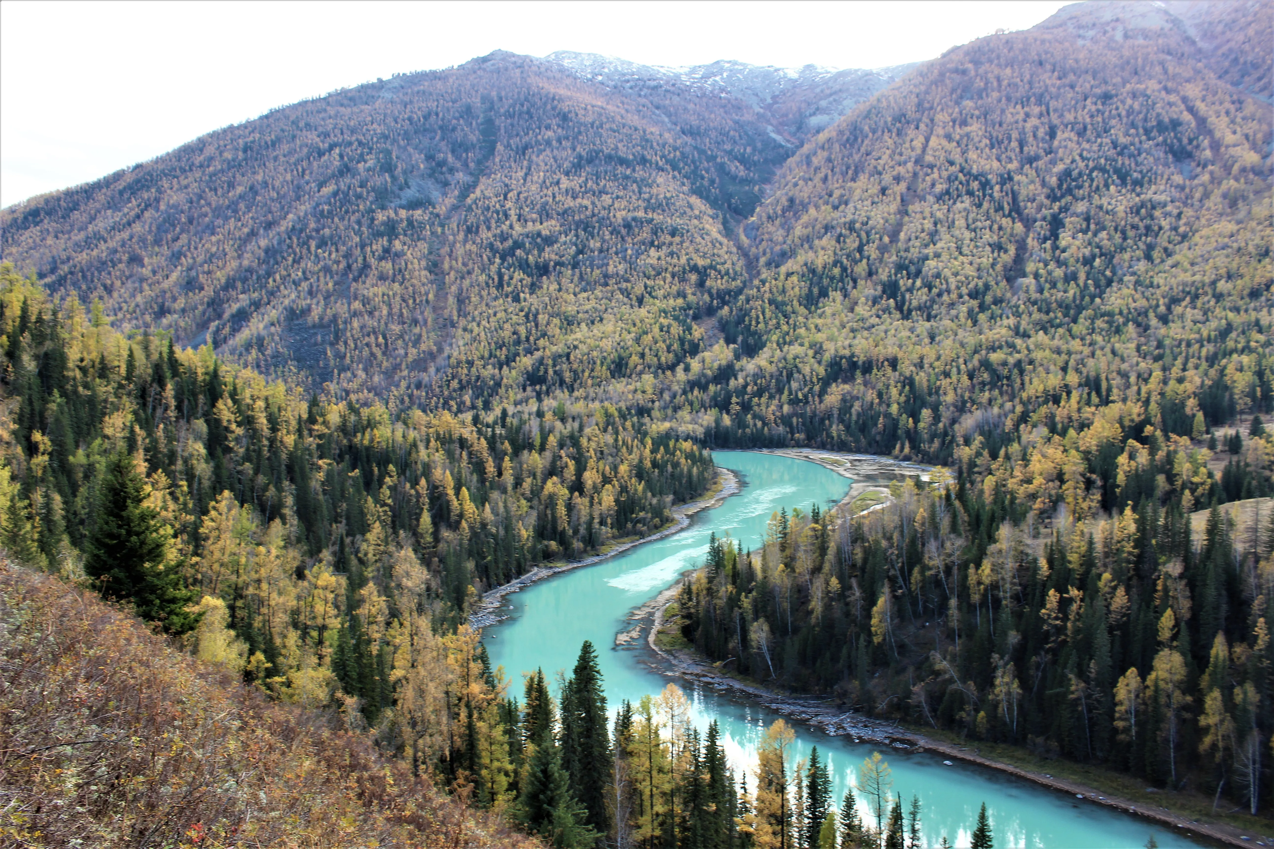
The geography made this route both logical and treacherous. To the north lay the Taklamakan Desert, one of the most unforgiving expanses on Earth, where shifting sand dunes could swallow entire caravans. To the south rose the Kunlun wall, impassable without specialized equipment and acclimatization. Between the two, a narrow corridor of oasis cities provided the only reliable passage: Hotan, Yarkand (Shache), Kashi(Kashgar) — each one a node of trade, religion, and cultural exchange that would have been impossible without the glacial meltwater flowing down from the mountains above.
The Kunlun were not merely a backdrop to this trade. They were its infrastructure. The same glaciers that supplied water to the oasis cities also produced the jade that flowed eastward along the same route, funding the entire trading system. The mountains that looked impassable were, in fact, the reason the route was possible at all.
This was the terrain that Xuanzang crossed in the 7th century on his way back from India, manus secured against the cold. This was the landscape that Marco Polo described in the 13th century — the high deserts, the jade rivers, the oasis cities where every road seemed to lead. Neither man climbed the Kunlun. Both traveled in its shadow, guided by its meltwater, sheltered from the desert by its mass.
That relationship — the mountain as guardian rather than destination — defines the Kunlun's role in the Silk Road story. You do not conquer the Kunlun. You travel alongside it, and the journey is the point.
4. What Does the Kunlun Mountain Landscape Actually Look Like?
The Kunlun is not one landscape. Over its 3,000-kilometer length, it passes through three distinct geographic zones, each with its own character.
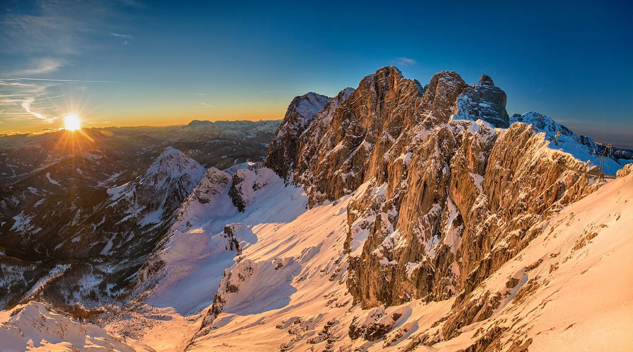
The Western Kunlun borders the Pamir Plateau and merges with the Karakoram system near Kashi(Kashgar) and Tashkurgan. This is the most dramatically glaciated section of the range — a world of serrated ice peaks, permanent snowfields, and high-altitude valleys where the air is thin enough to make every step feel considered. The Muztagata (Muztagh Ata) glacier system dominates this zone, rising to over 7,500 meters and visible on clear days from the Karakoram Highway, one of the most scenically extraordinary roads on Earth.
The Central Kunlun runs along the northern edge of the Tibetan Plateau, where the landscape becomes more austere. This is a zone of high-altitude plains, alkaline lakes, and vast silences — not dramatic in the way of jagged peaks, but overwhelming in scale. Colors here shift in ways that seem impossible: rust-red volcanic rock against white salt flats, steel-blue lakes under a sky that feels several shades darker than it should. Few travelers reach this section independently.
The Eastern Kunlun, running through Qinghai province, is the most accessible stretch of the range. Elevations are lower, roads are better, and it is here that the mountain system begins to transition from the Tibetan world into the more familiar geography of inland China. The Kunlun Mountain Pass (昆仑山口) on the Qinghai-Tibet Highway sits at 4,767 meters and is one of the few points where a traveler can stand at the Kunlun and feel the full weight of what the range represents.
The entire range is also geologically active. In 2001, an 8.1-magnitude earthquake — one of the largest ever recorded on land — struck the central Kunlun, leaving a surface rupture that stretched for over 400 kilometers and is now recognized as part of a UNESCO geological heritage site. The fault scar is still visible from the air, a reminder that these mountains are not ancient and finished, but actively in the process of becoming.
5. How to Experience the Kunlun Mountains Today
The Kunlun is not an easy destination. But that is precisely why the experience, for those who make it, tends to be genuinely transformative rather than merely scenic.
Best Season: June to September
The window for travel in the Kunlun region is narrow. Snow closes many high passes from October through May, and even in midsummer, temperatures at altitude can drop sharply overnight. July and August offer the most reliable conditions, with maximum daylight and the best chance of clear skies. September brings the added reward of autumn colors in the lower valleys and a noticeable thinning of tourist numbers.
Main Entry Points
From Kashi(Kashgar), heading south into the Pamir Plateau gives access to the western Kunlun, including the Tashkurgan valley and the approach to Muztagata. The Karakoram Highway is one of the world's great road journeys, and this route follows it southward into terrain that has changed surprisingly little since the Silk Road era.
From Golmud (格尔木), heading south puts you on the Qinghai-Tibet Highway, with the Kunlun Mountain Pass accessible as a day trip. This is the most straightforward way to stand at the Kunlun for travelers approaching from eastern China.
From Hotan, along the northern foot of the range, the old Southern Silk Road route is still driveable as a series of connected highways. This is the route that most closely replicates the historical Silk Road experience — oasis towns, desert edges, and the Kunlun wall rising to the south throughout.
Self-Drive vs. Guided Tour vs. Train
Self-driving in Xinjiang and Qinghai requires careful preparation: permits for certain areas, reliable high-clearance vehicles, and contingency plans for altitude sickness and road closures. It offers maximum flexibility, but the logistics overhead is significant.
Guided tours simplify logistics but often compress the experience into a series of scheduled stops, leaving little room for the kind of unhurried engagement that these landscapes demand.
A third option — one that has been gaining traction among travelers who want depth without logistical burden — is the dedicated Silk Road train journey, which we cover in the next section.
Altitude Considerations
Anywhere along the Kunlun range, altitude is a serious factor. Even the accessible eastern passes sit above 4,500 meters. Standard advice applies: ascend gradually, stay hydrated, avoid alcohol for the first 48 hours at altitude, and do not underestimate symptoms of acute mountain sickness. Acetazolamide (Diamox) is widely used by travelers to this region as a preventive measure, though medical advice should be sought before use.
Gear essentials include sun protection rated for high UV environments, windproof layering regardless of season, and quality footwear for uneven terrain. A satellite communication device is strongly recommended for any travel away from main roads.
6. The Silk Road Express: Tracing the Kunlun Route by Train
The way modern travelers experience the Silk Road is changing.
For most of the 20th century, a journey along the ancient trade routes meant either a grueling overland drive or a series of disconnected flights between oasis cities — efficient, perhaps, but bearing no relationship to the rhythm and continuity that defined the original journey. The Silk Road was always about movement through landscape, not arrival at destinations. Something was always lost in translation.
The Silk Road Express restores that continuity. Running a 17-day, 16-night itinerary through northern and southern Xinjiang, the train traces precisely the corridor that the ancient Southern Silk Road followed — along the northern face of the Kunlun, through the oasis cities that the mountains made possible, and into the landscapes that Xuanzang and Marco Polo described from the same vantage point centuries apart.
The train's route through the Kunlun influence zone covers the range's most historically significant stops: Kashi(Kashgar) and Tashkurgan in the western Kunlun foothills, where the Pamir glaciers are visible on clear days; Hotan, the ancient jade capital whose entire existence depended on Kunlun meltwater; and Hami and Turpan further east, where the Silk Road began its turn northward away from the mountains.
What the train offers that no other format can replicate is the experience of continuity. The Kunlun does not reveal itself in a single dramatic moment — it unfolds across hundreds of kilometers, shifting from glaciated western peaks to austere central plains to the more accessible eastern ranges. Seen through the panoramic windows of the Silk Road Express, that unfolding happens at the pace it was always meant to be experienced: slowly, deliberately, with the landscape as the narrative.
The windows have been described, not inaccurately, as a moving IMAX screen. Snow peaks give way to desert, desert gives way to oasis, oasis gives way to the next mountain wall — and the passenger, warm and unhurried inside the carriage, watches the entire story play out without leaving their seat.
The itinerary includes dedicated shore excursions into the landscapes that the train passes through: a VIP off-road crossing of the Hami wilderness, deep-dive visits to the Xinjiang Regional Museum with specialist guides, and optional routes into the Pamir Plateau from Kashi(Kashgar). The mountains are not merely scenery from the window — they are the destination, reached on the range's own terms.
You don't climb the Kunlun. You travel alongside it — and that journey alone is enough.
The Kunlun Mountains will not give themselves to you easily. They are too large, too ancient, and too indifferent to the expectations of visitors for that. But for travelers willing to approach them on their own terms — slowly, with the right route and the right frame of mind — they offer something that the more famous ranges of Asia rarely can: the feeling of being genuinely inside history, moving through a landscape that has not fundamentally changed since the first caravans passed this way two thousand years ago.
That is what the Silk Road has always promised. The Kunlun is where that promise is kept.
Frequently Asked Questions
Q: Where are the Kunlun Mountains located?
The Kunlun Mountains stretch approximately 3,000 kilometers across the heart of Central Asia, running through China's Xinjiang, Xizang, and Qinghai provinces. The range begins at the Pamir Plateau in the west — where it borders Tajikistan and Afghanistan — and extends eastward to the borders of Sichuan. It forms the natural boundary between the Tarim Basin and the Tibetan Plateau, separating the Taklamakan Desert to the north from the world's highest plateau to the south.
Q: Are the Kunlun Mountains higher than the Himalayas?
As a range, no — the Himalayas contain the world's highest individual peaks, including Everest at 8,849 meters. However, the Kunlun are not as low as their relative obscurity might suggest. The highest Kunlun peak, Liushi Shan, reaches 7,649 meters — taller than anything in North America, Europe, or Antarctica. The average elevation of the Kunlun range, at 5,500 to 6,000 meters, is comparable to the broader Himalayan system. What the Kunlun lacks in record-breaking summits, it more than compensates for in sheer length and geographic scale.
Q: What is the significance of the Kunlun Mountains in Chinese culture?
The Kunlun hold a place in Chinese culture that has no direct Western equivalent. Known as 万山之祖 — the Ancestor of All Mountains — they were understood in ancient Chinese cosmology as the axis of the world, the point where heaven and earth met. In Taoist mythology, the Kunlun were home to Xi Wangmu, the Queen Mother of the West, whose palace sat at the summit and whose peaches granted immortality. The mountains are also inseparably linked to jade: the white nephrite jade that has defined Chinese material culture for over five thousand years comes largely from rivers flowing down from the Kunlun into the Hotan region of Xinjiang. In short, the Kunlun shaped Chinese mythology, philosophy, and material culture simultaneously — a combination that makes them uniquely foundational in the Chinese cultural imagination.
Q: Can tourists visit the Kunlun Mountains?
Yes, though access varies significantly depending on which section of the range you intend to visit. The eastern Kunlun, particularly the Kunlun Mountain Pass on the Qinghai-Tibet Highway near Golmud, is the most accessible entry point and can be reached without special permits. The western Kunlun, including the Pamir Plateau and the approaches from Kashi(Kashgar) and Tashkurgan, is also open to tourists but requires more logistical planning. Certain areas along the range require border zone permits, which must be arranged in advance. Independent travel is possible but demands solid preparation; guided tours and specialist itineraries — including dedicated Silk Road train journeys — are increasingly popular options for travelers who want to experience the range without managing the logistics themselves.
Q: What is the best time to visit the Kunlun Mountains?
June to September is the recommended window. Snow closes many high passes from October through May, and even in summer, overnight temperatures at altitude can drop sharply. July and August offer the most reliable weather conditions and maximum daylight hours. September is particularly rewarding — the crowds thin noticeably, the light takes on a warmer quality, and the lower valleys show early autumn color. Whenever you travel, layering is essential: the Kunlun's high-altitude environment means temperature swings of 20°C or more between midday and midnight are not uncommon.
Q: How do the Kunlun Mountains relate to the Silk Road?
The relationship is foundational. The Southern Silk Road — one of the ancient trade network's most important routes — ran directly along the northern foot of the Kunlun for much of its length. The oasis cities that made this route possible, including Hotan, Yarkand, and Kashi(Kashgar), existed because of glacial meltwater flowing down from the Kunlun into the surrounding desert. Without the mountains, there would have been no water; without the water, there would have been no oases; without the oases, the route would have been impassable. Figures as historically significant as Xuanzang and Marco Polo both traveled in the shadow of the Kunlun along this corridor. The mountains were never the destination — they were the reason the journey was possible at all.