Xinjiang Map: The Ultimate 2026 Tourist Guide & Route Planner
If you've ever pulled up a map of China and tried to locate Xinjiang, you'll understand why planning a trip here requires more preparation than almost anywhere else in the country. Xinjiang is vast — genuinely, almost incomprehensibly vast. Covering approximately 1.66 million square kilometres, it accounts for roughly one-sixth of China's total land area, making it larger than France, Spain and Germany combined, and nearly five times the size of Japan.
That scale has real implications for how you travel. Distances that look manageable on a standard map turn out to be full-day journeys. Attractions that appear close together can be separated by eight hours of road. The single most common mistake first-time visitors make in Xinjiang is underestimating how far apart everything actually is — and paying for that miscalculation in exhausting, wasted travel days.
This guide is built around the map. Before we discuss what to see, we'll make sure you understand where everything is, how the region is divided, and how to navigate its scale in a way that leaves time for the experiences that make Xinjiang worth the journey in the first place.
Where Is Xinjiang Located?
Xinjiang — officially the Xinjiang Uygur Autonomous Region — sits in the far northwest of China, as remote from Beijing as London is from Moscow. It shares borders with eight countries: Mongolia to the northeast, Russia to the north, Kazakhstan, Kyrgyzstan and Tajikistan to the west, Afghanistan and Pakistan to the southwest, and India to the south. No other region in China shares borders with as many nations, and that geopolitical position is not merely a cartographic curiosity — it's the reason Xinjiang became one of the most culturally layered places on earth.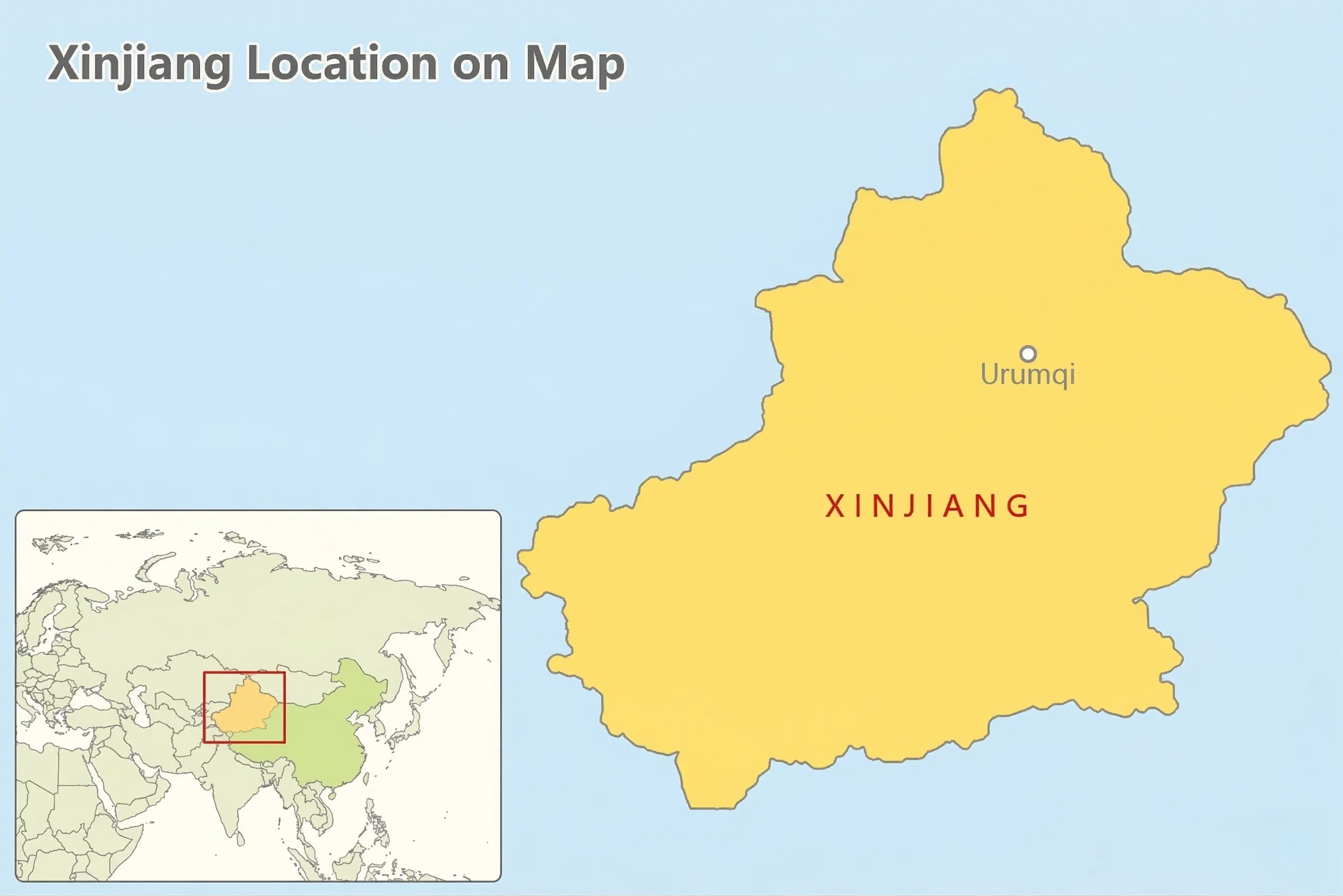
The region is landlocked and sits deep in the interior of the Eurasian continent, further from any ocean than almost any point on the planet. This geographic isolation shaped its climate (extreme temperature swings, very low rainfall), its history (a succession of empires that each left cultural traces), and its identity as the crossroads where Chinese, Central Asian, Persian and Turkic civilisations converged for over two millennia.
[Map: Xinjiang location within China and relative to Central Asian borders]
For travellers arriving from the east, the psychological shift on entering Xinjiang is immediate — the architecture, the language heard on the streets, the food, the scale of the landscape. The map alone cannot convey this. But understanding where Xinjiang sits — on the edge of China, at the centre of Asia — is the essential starting point.
Northern vs. Southern Xinjiang: Understanding the Map
The single most important geographical concept for any visitor planning a Xinjiang itinerary is the division between North and South — and the mountain range that separates them.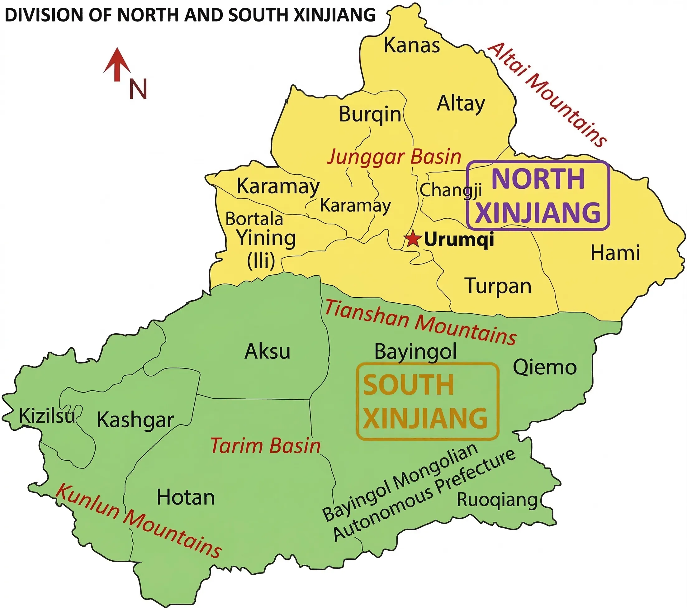
The Tianshan Mountains (天山) run roughly east to west through the heart of Xinjiang, forming a natural wall that divides the region into two fundamentally different worlds. Understanding this division will save you from the most common itinerary mistake: trying to see both halves in one trip without accounting for the distance between them.
Northern Xinjiang (北疆) — Grasslands, Lakes and Natural Grandeur
North of the Tianshan lies the Dzungarian Basin (準噶爾盆地), a landscape of sweeping grasslands, alpine lakes, and dense forests that bears more resemblance to the steppes of Central Asia than the arid interior of China. The light here is different — softer, greener, more European in quality — and the scenery is defined by wide open spaces rather than dramatic desert formations.
Northern Xinjiang is where you'll find Xinjiang's most celebrated natural landscapes: the mirror-calm waters of Kanas Lake in the Altai Mountains, the turquoise expanse of Sayram Lake beside the Tianshan pass, and the Nalati Grasslands where Kazakh nomadic culture survives in a form relatively unchanged for centuries. The region is cooler and wetter than the south, with four distinct seasons that bring wildflowers in spring, golden larches in autumn, and deep snowfall in winter.
Southern Xinjiang (南疆) — History, Culture and the Ancient Silk Road
South of the Tianshan lies the Tarim Basin (塔里木盆地), one of the largest enclosed basins on earth and home to the Taklamakan Desert — whose name in Uygur is often translated as "you go in, you don't come out." The landscape here is arid, ancient and theatrical: red-rock canyons, crumbling Han dynasty watchtowers, oasis cities that have been trading posts for two thousand years.
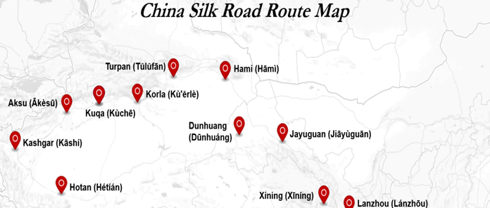
Southern Xinjiang is where the Silk Road's cultural legacy is most tangible. The cities of Kashi(Kashgar), Kucha, Turpan and Hotan were not merely stops on a trade route — they were civilisational centres, each with its own distinct language, architecture, music and culinary tradition. The Uygur culture is most concentrated here, and the bazaars, mosques and old city streets of the south carry a sensory richness that is unlike anywhere else in China.
The practical implication for your itinerary: North and South Xinjiang are not just geographically different — they require a conscious choice. Attempting to cover both in under two weeks typically means sacrificing depth for distance. Most experienced travellers recommend dedicating a full trip to one region, or building a generous 17–21 day itinerary if you intend to experience both properly.
Xinjiang Tourist Map: Top Attractions by Region
With the North/South division in mind, here are the key destinations that anchor any serious Xinjiang itinerary — and what makes each one worth the journey.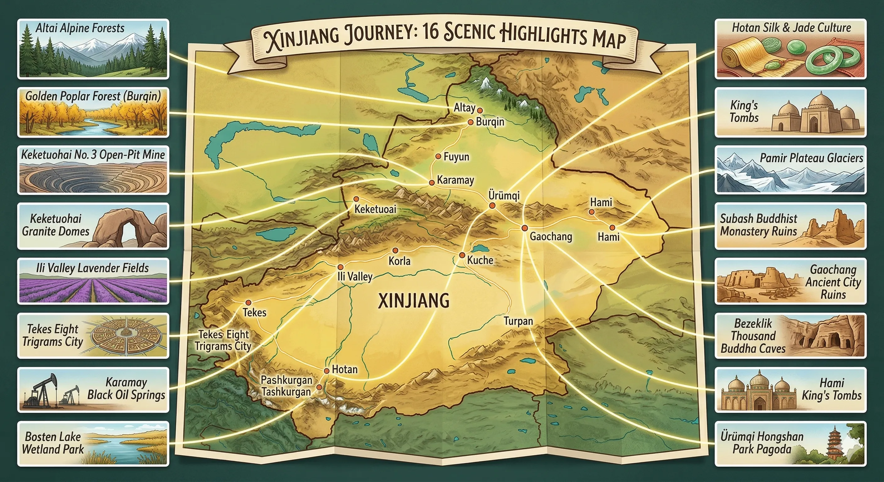
Northern Xinjiang
Kanas Lake (喀納斯湖) Located in the Altai Mountains near the borders of Russia, Mongolia and Kazakhstan, Kanas Lake is one of the most visually dramatic natural sites in China. The lake's depth and mineral composition give the water an extraordinary colour that shifts between blue, green and gold depending on the season and light. Autumn — when the surrounding larches turn orange and red — is widely considered the most spectacular time to visit. Kanas is remote even by Xinjiang standards, requiring either a flight to Burqin or a very long drive from Ürümqi, and the area rewards at least two or three nights.
Sayram Lake (賽里木湖) Sitting at 2,073 metres above sea level on the northern slopes of the Tianshan, Sayram is the largest alpine lake in Xinjiang and one of the most accessible natural highlights in the north. The lake sits directly beside the main road connecting Ürümqi to the Ili valley and the Kazakh border, making it a natural stopping point on any northern circuit. In summer, the surrounding meadows are dense with wildflowers and grazed by the sheep and horses of Kazakh herding families.
Ürümqi (烏魯木齊) The regional capital and the practical hub for most Xinjiang itineraries — not a destination in itself, but an essential logistics base. Tianchi (Heaven Lake), located about 110 kilometres east of the city, is worth a day trip if time permits.
Southern Xinjiang
Kashgar Old City (喀什老城) Kashgar is the cultural and emotional heart of southern Xinjiang, and one of the most historically significant cities on the entire Silk Road. The old city — a dense, organic maze of mud-brick architecture, artisan workshops and narrow alleys — has been inhabited continuously for over two thousand years. The Id Kah Mosque, one of the largest in China, anchors the old city's main square, where the rhythms of daily life have a quality that feels genuinely ancient. The Sunday livestock market on the city's outskirts remains one of the great Central Asian bazaar experiences, drawing traders from across the region as it has done for centuries.
Kucha / Kuqa (庫車) Kucha is one of the most historically layered cities in Xinjiang, and one of the least visited by international travellers — which makes it particularly rewarding for those willing to make the detour. The ancient kingdom of Kucha (Kuche or Qiuci in historical sources) was a major centre of Silk Road Buddhist culture; the surrounding area contains some of the oldest Buddhist cave complexes outside of India, including the Kizil Caves, whose murals predate those at Dunhuang by several centuries. The old city itself retains an unhurried, authentic quality that the more touristically developed cities of the south have partly lost.
Turpan (吐魯番) Sitting in a depression 154 metres below sea level — the second-lowest point on earth after the Dead Sea — Turpan is one of the hottest and driest inhabited places in the world, and one of the most historically interesting. The ruined cities of Jiaohe and Gaochang, both dating back over two thousand years, rise from the desert floor like architectural fossils. The Flaming Mountains, made famous in the Chinese novel Journey to the West, glow a deep red-orange in the afternoon sun. The karez irrigation system — an extraordinary feat of ancient hydraulic engineering that channels glacial meltwater underground across hundreds of kilometres — explains how this oasis city survived and thrived in an otherwise uninhabitable landscape.
Xinjiang Transport Map: Airports and Train Stations
Understanding Xinjiang's transport infrastructure is as important as knowing its geography. Given the region's scale, your entry point and internal connections will shape your entire itinerary — and getting this wrong can cost you days.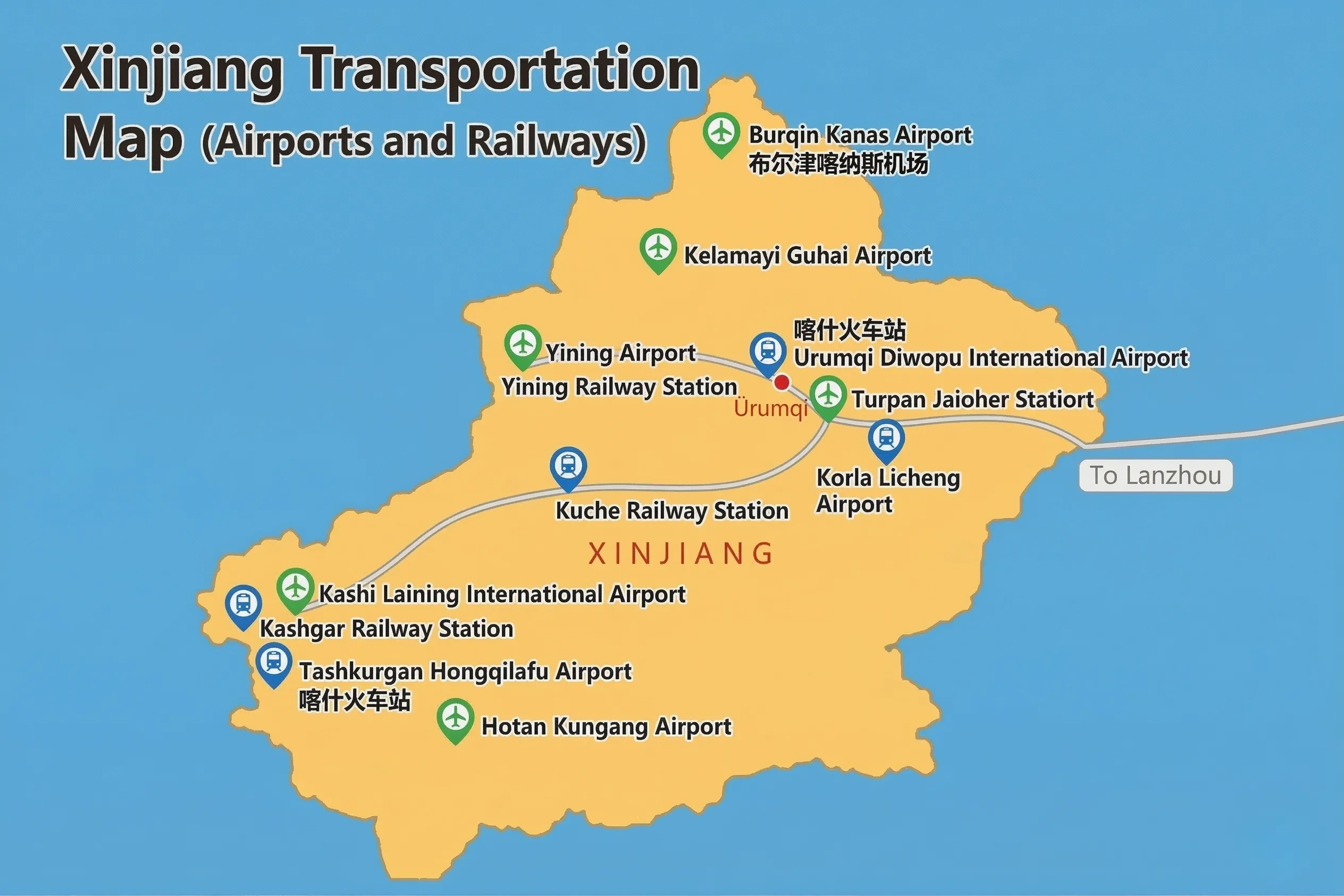
Airports
Xinjiang has several commercial airports, but three are the most relevant for international and long-haul domestic travellers:
Ürümqi Diwopu International Airport (乌鲁木齐地窝堡国际机场) is the primary gateway into Xinjiang and the region's main hub. Direct flights connect Ürümqi to Beijing, Shanghai, Chengdu, and a number of Central Asian cities. For most visitors, this is the most practical entry point, particularly if combining a Xinjiang trip with other Chinese destinations.
Kashgar Airport (喀什机场) serves the southern end of the region and is particularly useful for travellers focusing on Southern Xinjiang. Domestic flights connect Kashgar to Ürümqi, and increasingly to major eastern cities, making a fly-in/fly-out southern itinerary viable without backtracking north.
Yining Airport (伊宁机场) serves the Ili valley in the northwest, offering access to Sayram Lake and the Nalati grasslands without the need to route through Ürümqi. Useful for travellers prioritising the western section of Northern Xinjiang.
Additional airports at Hotan,Kucha( Kuqa), Aksu and Altay serve more remote destinations and are primarily used for domestic connections within the region.
Train Stations
Rail is the backbone of long-distance travel within Xinjiang, and understanding the main stations will help you plan connections efficiently.
Ürümqi Railway Station and Ürümqi South Station(乌鲁木齐站和乌鲁木齐南站) are the region's primary rail hubs, connecting Xinjiang to the national high-speed network via Lanzhou and Xining to the east. Most long-distance trains into and out of Xinjiang pass through one of these two stations.
Turpan North Station (吐鲁番北站) sits on the main high-speed line between Ürümqi and Kashgar, making Turpan one of the most accessible stops on a southern Xinjiang rail itinerary — less than an hour from Ürümqi by high-speed train.
Kucha(Kuqa) North Station (库车北站) provides rail access to the ancient Buddhist sites of the Kuqa region, roughly halfway along the Ürümqi–Kashgar high-speed line.
Kashi(Kashgar) Railway Station (喀什站) is the western terminus of the Xinjiang high-speed network, sitting at the edge of the Tarim Basin. The journey from Ürümqi to Kashgar takes approximately five to six hours on the high-speed service — a remarkable achievement of modern infrastructure across some of the world's most challenging terrain.
Xinjiang Climate and Best Time to Visit
Xinjiang's climate is one of the most extreme in China — and one of the most misunderstood by first-time visitors. The region's deep continental position means temperature swings between seasons, and even between morning and evening within a single day, can be dramatic. Planning around the climate is not optional here; it is one of the most important decisions you will make.
The General Pattern
Xinjiang has a classic continental climate: hot, dry summers and cold winters, with very low annual rainfall across most of the region. The desert basins of the south (Tarim, Turpan) experience some of the most extreme heat in China during summer, while the northern grasslands and mountain zones are significantly cooler and receive more precipitation.
One local saying captures the climate well: "Four seasons in one day, different weather across ten miles." Temperature differences between day and night regularly exceed 15–20°C, particularly in spring and autumn. Packing layers is not a travel cliché in Xinjiang — it is a practical necessity.
Season by Season
Spring (April – May) brings warming temperatures and the first wildflowers to the northern grasslands, but can be unpredictable — dust storms are not uncommon in the desert regions, and mountain roads may still be partially closed from winter snowfall. Early April is generally too cold for comfortable travel in the north. Late May is one of the most beautiful periods in the Ili valley, when the rapeseed fields are in full bloom.
Summer (June – August) is peak season across Northern Xinjiang. Kanas Lake, the Nalati grasslands, Sayram Lake and Hemu village are at their most vivid — wildflowers in full bloom, long daylight hours, and the Kazakh herding culture at its most active. In Southern Xinjiang, summer is a different story: Turpan regularly reaches 45°C in July and August, making daytime sightseeing genuinely difficult. Dunhuang and the desert regions are similarly intense. If visiting the south in summer, early morning activity and afternoon rest is the practical approach.
Autumn (September – October) is widely considered the single best season to visit Xinjiang, particularly the north. The larches around Kanas Lake turn gold and orange from mid-September, producing the landscapes most commonly seen in photographs of the region. Temperatures are mild, skies are consistently clear, and the summer crowds have thinned. For anyone with flexibility in their travel dates, late September to mid-October in Northern Xinjiang is hard to improve upon. Southern Xinjiang is also excellent in autumn — Kashgar and the Pamir region are comfortable, and the harvest season brings additional life to the bazaars and markets.
Winter (November – March) transforms Northern Xinjiang into a snow-covered landscape that is beautiful but logistically demanding. Many scenic areas around Kanas reduce their services or close entirely. The southern cities — Kashi(Kashgar), Kucha(Kuqa), Hotan — remain accessible year-round and are actually pleasant in winter by comparison, with mild days and far fewer visitors. For travellers who want to experience Xinjiang without the summer crowds and are comfortable with cold, a winter visit to Southern Xinjiang offers a genuinely different perspective.
Quick Reference by Destination
Kanas Lake & Northern Grasslands — Best: late September to mid-October (autumn colour) and June to August (wildflowers, full services)
Kashgar & Southern Xinjiang — Best: April to June and September to November; avoid July–August heat
Turpan — Best: April to May and September to October; July–August temperatures are extreme
Pamir Plateau (Tashkurgan, Karakul Lake) — Best: June to September; road conditions and altitude make winter visits impractical
The Real Challenge of Navigating the Xinjiang Map
Here is something most travel guides won't tell you upfront: a short distance on a Xinjiang map bears almost no relationship to the time it takes to travel it. A stretch that looks like two inches on paper can translate to ten hours on a highway. Cities that appear neighbouring are often separated by vast, empty desert or mountain terrain that offers no shortcuts.
This isn't a reason to avoid Xinjiang. It's simply a reason to plan it differently from any other destination you've visited.
Independent travellers who build their itinerary around road transport often find that a disproportionate amount of their trip is spent in transit — watching the same desert highway pass by for hours — rather than at the destinations themselves. The distances are not the problem; the mistake is trying to fight them rather than work with them.
The most experienced Xinjiang travellers tend to arrive at the same conclusion: the key is choosing a mode of travel that turns the distance into part of the experience, rather than an obstacle to it.
Xinjiang by Rail: A Smarter Way to Read the Map
China's rail network has transformed travel across Xinjiang over the past decade. The high-speed line connecting Ürümqi to Kashi(Kashgar) — a journey that once required an overnight bus or a full day by road — now takes under six hours by train, running through some of the most dramatic desert and mountain scenery in Central Asia.
For travellers who want to cover both Northern and Southern Xinjiang without sacrificing depth at either end, the train resolves what would otherwise be an impossible logistical puzzle. You move between regions overnight or across a morning, arriving rested rather than road-worn, with your full attention available for the place you've just reached.
This is precisely the approach behind the Silk Road Express by Train of Glamour — a 17-day itinerary that traces the full arc of the Xinjiang map, from the Tibetan Plateau gateway of Xining through the northern alpine landscapes of Kanas and Sayram Lake, across to the ancient Silk Road cities of Kuqa and Kashgar, and into the high Pamir plateau beyond. The train handles the distances; the destinations handle the rest.
Start Planning Your 2026 Xinjiang Journey
A Xinjiang map is, in one sense, just a collection of names and coordinates. But each of those names represents something that resists easy deion — the particular quality of light on Kanas Lake in early autumn, the sound of the call to prayer echoing through Kashgar's old city at dusk, the silence of the Taklamakan stretching to every horizon.
The map will show you where to go. Getting there is a separate question — and one worth thinking carefully about before you begin.